

Effective operation and improving the function of MDA Situational Indication Linkages (MSIL)
Organizations: Cabinet Secretariat, Cabinet Office, Ministry of Education, Culture, Sports, Science and Technology, Ministry of Economy, Trade and Industry, Ministry of Land, Infrastructure, Transport and Tourism, Ministry of the Environment, Ministry of Defense, National Research Institute for Earth Science and Disaster Resilience (NIED), Japan Aerospace Exploration Agency (JAXA), Japan Agency for Marine-Earth Science and Technology (JAMSTEC), National Institute of Polar Research, and others
Developed within a framework of general coordination provided by the Cabinet Office, this is an information service designed to aggregate various types of ocean-related information held by relevant ministries and agencies as well as governmental organizations and display them on a map with the aim of enabling their use in different fields, such as in maritime safety, measures to deal with natural disasters, conservation of the ocean environment, and the promotion of marine industries.
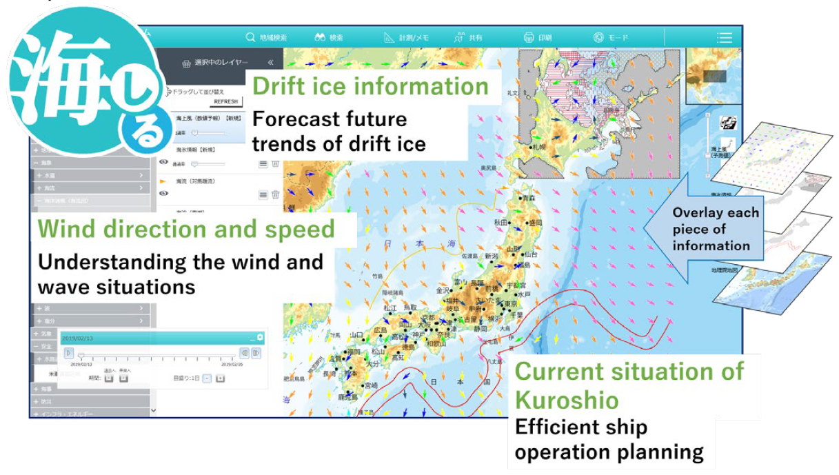
Reference: MDA Situational Indication Linkages (MSIL) (https://www.msil.go.jp/)
The Nippon Foundation-GEBCO Seabed 2030 Project
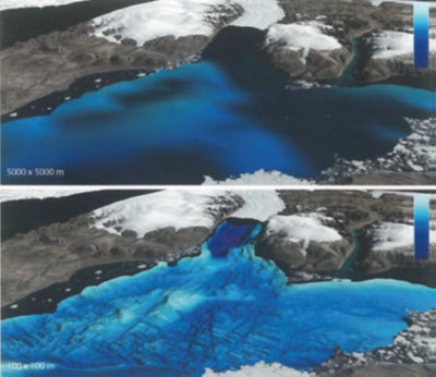
Finding out about the details of seafloor topography around a fjord helps to determine the effect of the ocean current on the melting of the fjord. (Comparison in terms of resolution between 5,000 m x 5,000 m (top) and 100 m x 100 m (bottom))
The Nippon Foundation-GEBCO Seabed 2030 Project is a collaborative project between The Nippon Foundation and the General Bathymetric Chart of the Oceans (GEBCO) to complete the map of the world’s ocean floor by 2030.
Information about the topography of the ocean floor is useful in a wide range of fields including prediction of currents and tsunamis, safety of navigation, prediction of rise in sea levels, and monitoring of marine organisms. However, in 2017 when the Seabed 2030 project started, only 6% of the world’s ocean floor had been mapped according to modern standards. With the establishment of the Global and Regional Data Centers in different parts of the world and cooperation from governments, international organizations, academic institutions and corporations, the project had managed to increase the percentage of the world’s ocean floor that is mapped to 19% by 2020. It is hoped that mapping of yet unexplored parts of the world could be facilitated through the establishment of new partners across different disciplines.